San Diego Faces Unseasonably Warm Midweek Temperatures as Santa Ana Winds Raise Fire and Travel Concerns
Warm, dry pattern builds over the county
San Diego County is entering a short-lived but notable warm spell, with temperatures forecast to run well above early-February norms as offshore flow strengthens. The warmest conditions are expected midweek, with many inland communities rising into the 80s and coastal locations also trending warmer than typical for this time of year.
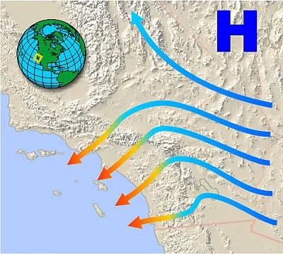
The pattern is being driven by high pressure and an offshore pressure gradient that favors Santa Ana winds—dry, downslope winds that warm as they descend from higher terrain. While the strongest winds are often most pronounced along and below mountain passes and foothills, the warming can extend across much of the region, including coastal neighborhoods.
Where the heat and wind may be most noticeable
Forecast temperatures indicate a sharp midweek peak, followed by a step down later in the week as onshore flow gradually returns. In practical terms, the largest temperature departures from normal typically occur in the inland valleys, foothills and lower deserts, while coastal areas can also see unusually warm afternoons when the marine layer is suppressed.
Wind impacts are expected to be uneven. Gustier conditions frequently concentrate in wind-prone passes and canyons, with lighter but still drying breezes spilling into adjacent valleys and, at times, reaching the coastal strip. The combination of low humidity and intermittent gusts can accelerate drying of vegetation and increase the sensitivity of the landscape to any ignition source.
Fire-weather implications: dryness is the primary concern
Even when wind speeds are not extreme across the entire county, Santa Ana setups commonly reduce relative humidity and limit overnight moisture recovery. That can elevate fire-weather risk, particularly near foothills and in brushy areas where fuels can respond quickly to warm, dry air.
Any official fire-weather alerts are issued based on local thresholds that consider wind, humidity and fuel conditions. Residents should monitor for changing advisories, especially if winds strengthen overnight into the morning hours, when offshore gradients can be most pronounced.
- Secure lightweight outdoor items that can be displaced by gusts.
- Use extra caution driving high-profile vehicles on exposed routes near passes.
- Avoid activities that can create sparks in dry vegetation, including some yard and equipment use.
Timing: brief warm spike, then cooling trend
Current outlooks point to the warmest day arriving around Wednesday, February 4, 2026, before temperatures ease back toward the weekend. A return of marine influence typically brings cooler afternoons and a higher chance of night and morning clouds along the coast.
Key takeaway: Midweek warmth and dry offshore winds are expected to be the most consequential combination, particularly for foothill and valley communities.
While the warm spell is expected to be temporary, the wind-driven dryness can produce outsized impacts on comfort, air quality near sensitive areas, and day-to-day safety planning until the offshore flow weakens.